
Saturday, May 14, 2016
Swift Interview
Just a quick update as promised. The Swift interview will air May 21 at 8:00 PM on KET. The last entry on this site covered the interview and location of the taping. If you are interested in learning about the treasure and see yours truly yacking about the legend, tune in on May 21st.

Wednesday, April 27, 2016
Swift Interview
It was a very interesting day April, 26. A production crew from KET (Kentucky Educational Television) taped a segment of yours truly discussing the background and lore around the famous legend of John Swift and his mysterious silver mines and treasure. I met up with the crew at Sky Bridge in the Red River Gorge and after a short hike down beneath the rock arch they video taped me discussing what I have come to know about the search and treasure.
Basically, the short segment will focus more on the legends background and how long the story has been around rather than giving clues on searching for the supposedly hidden treasure. I hope that viewers will take away the importance of the history of the legend and not the debate whether silver and the mines ever existed. As I note in the interview, the beauty of the whole legend is just how long the search has been going on and how the legend originated at least as early as the first famous pioneers entered the wilderness that was to become Kentucky.
It could not have been a better day for being in the great outdoors. And it is always great enjoyment for me to get back into the Red River country. The spot chosen was interesting enough near the mouth of Swift Creek which takes its name from the legendary character and tale of lost treasure. It was a fun experience and certainly a chance to acquaint new folks with the oldest treasure legend in Kentucky. At this time I do not know the air date of the episode but was promised I would be notified in advance. Hopefully, I will have enough advance notice to pass along the air dates here to those who may be interested.
And, of course, to all those serious and dedicated searchers out there that happen across this site I did the interview from the perspective that my interest and passion for the treasure story is the story itself. I admit that there are many out there still searching every spare moment and they know far more details and clues than I do. But, as I understand, this short episode will just provide and overview of the famous legend.
Thanks for stopping by the site and please browse through past posts. Many of them give more details and clues about the lost treasure as well as many other interesting places in Kentucky.
And if your are interested in a good story about the legendary treasure, check out my book Swift at Booklocker.com. It is a safe and secure place to by many great books that will promptly be shipped to you. You can also find the book at most popular online sites. The book can also be purchased through most bookstores. Thanks for stopping by.
Basically, the short segment will focus more on the legends background and how long the story has been around rather than giving clues on searching for the supposedly hidden treasure. I hope that viewers will take away the importance of the history of the legend and not the debate whether silver and the mines ever existed. As I note in the interview, the beauty of the whole legend is just how long the search has been going on and how the legend originated at least as early as the first famous pioneers entered the wilderness that was to become Kentucky.
 |
| KET production crew setting up for interview |
And, of course, to all those serious and dedicated searchers out there that happen across this site I did the interview from the perspective that my interest and passion for the treasure story is the story itself. I admit that there are many out there still searching every spare moment and they know far more details and clues than I do. But, as I understand, this short episode will just provide and overview of the famous legend.
Thanks for stopping by the site and please browse through past posts. Many of them give more details and clues about the lost treasure as well as many other interesting places in Kentucky.
And if your are interested in a good story about the legendary treasure, check out my book Swift at Booklocker.com. It is a safe and secure place to by many great books that will promptly be shipped to you. You can also find the book at most popular online sites. The book can also be purchased through most bookstores. Thanks for stopping by.
Monday, February 1, 2016
The Book
 |
More about the book and many interesting places and people are available on this blog site.
Wednesday, December 9, 2015
Mound People
It is perhaps one of the hottest days of the summer. And I am in western Kentucky and it seems to me to be even hotter. The trip is worth the heat and humidity though because I am visiting a very unique park. This park is devoted to the civilization that once occupied the Mississippi valley and central North America. Today's visit is to Wickliffe Mounds State Historic Site.

Located on the bluffs overlooking the Mississippi River in western Kentucky the park is the site of a once thriving small community of people that lived at the site around 1100 to 1250 A.D. or about 750 years ago. According to archaeological evidence the small village lasted about 150 years. There are four main mounds that comprise the park and each one was for a different purpose. Some were for burial of loved ones, like our cemeteries of today Others provided platforms for houses of person of status such as leaders of the community. And other earthen mounds appeared to be for ceremonial and business purposes.
Wickliffe Mounds has an archaeological excavations site of the apparently living areas of some of the community. Tools, foods they ate and how their homes were built and arranged have all been gleaned from the excavations of the site. These excavations were conducted in the 1930's by the then owner Fain King, an amateur archaeologist. Mr. King opened and operated the excavations as a tourist attraction. In 1983 the property was turned over to Murray State University which operated the site as a research center. In recent years Wickliffe Mounds was designated as a historic site and became part of the Kentucky State Park System.
We know understand that this prehistoric village was part of the Mississippian culture that thrived in the central part of North America. The people that lived in this small settlement were part of a bigger society that occupied the entire region with the largest city of the Mississippian people living in Cahokia Mounds in southern Illinois. Cahokia mounds built the same type of earthen mounds as the Wickliffe people except on a much larger scale.It is thought that as many as 20,000 people lived in the city. Wickliffe Mounds was simply a small satellite community much like small communities today are arranged on the outskirts of large cities.
The mound builders had developed an elaborate social structure. Agricultural practice of raising corn and other cultivated crops the Mississippian people were able to produce a surplus of food. With extra food being available specialized skills became possible just like our society of today. The mound builders transition their society from a hunter gatherer people to agricultural.
The open excavations are protected inside the main museum building along with a variety of exhibits that explain many of the tools and materials used in the everyday life of the Wickliffe people. The site is unique among Kentucky State Parks in that it is the only park completely dedicated to a prehistoric culture. The park also includes a small gift shop and picnic shelter and facilities.
While in the area on this visit a took a short ride over to the Ballard County wildlife management area and got a glimpse at some of the cypress swamps and waterways that are in this lowland region of Kentucky. As I am from Eastern Kentucky where the land is hilly to mountainous it is fascinating to me so see this totally different type of landscape in our beautiful state. Western Kentucky has a lot of interesting history and places to enjoy.

 |
| Park grounds with museum building |
Wickliffe Mounds has an archaeological excavations site of the apparently living areas of some of the community. Tools, foods they ate and how their homes were built and arranged have all been gleaned from the excavations of the site. These excavations were conducted in the 1930's by the then owner Fain King, an amateur archaeologist. Mr. King opened and operated the excavations as a tourist attraction. In 1983 the property was turned over to Murray State University which operated the site as a research center. In recent years Wickliffe Mounds was designated as a historic site and became part of the Kentucky State Park System.
 |
| Artist rendering of how mound may have been used |
 |
| Inside the museum at Wickliffe Mounds State Park |
The open excavations are protected inside the main museum building along with a variety of exhibits that explain many of the tools and materials used in the everyday life of the Wickliffe people. The site is unique among Kentucky State Parks in that it is the only park completely dedicated to a prehistoric culture. The park also includes a small gift shop and picnic shelter and facilities.
While in the area on this visit a took a short ride over to the Ballard County wildlife management area and got a glimpse at some of the cypress swamps and waterways that are in this lowland region of Kentucky. As I am from Eastern Kentucky where the land is hilly to mountainous it is fascinating to me so see this totally different type of landscape in our beautiful state. Western Kentucky has a lot of interesting history and places to enjoy.
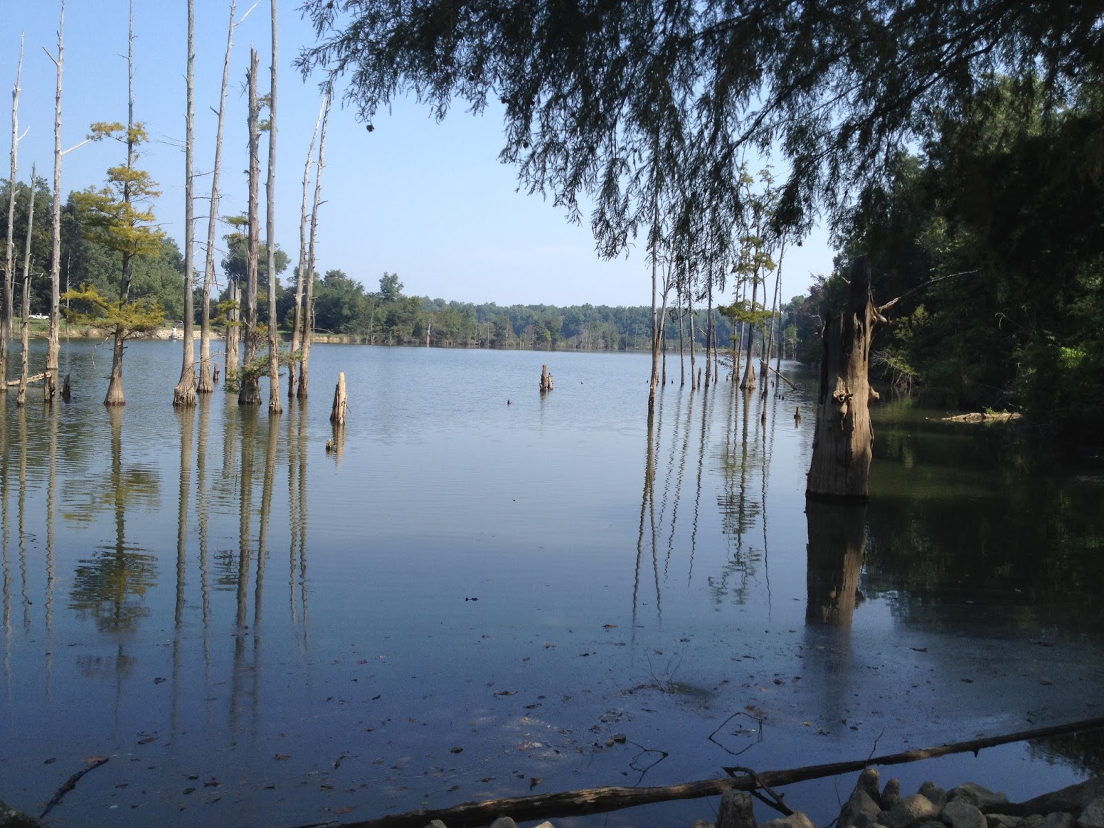 |
| Cypress grove in Ballard County, Ky |
Monday, August 31, 2015
Swift Blog Update
Hello to all. Thanks for stopping by my blog site. I hope you find articles and information that is interesting and helpful in your research or entertainment. I have not posted in some time now but rest assured I am working on some new posts for the near future.
As you may have figured out by now my interest in the geology and unique things of Kentucky is the main focus of this blog site. There are many other great sites that equally showcase amazing things from around out state. Some of my favorites are listed in the column on the right side of this page. You will also find links to my book publisher. And there you go, another reason for this site. I do want to promote my book "Swift." I have from time to time promoted the book as a blog entry. Well, I am going to do that again in this post.
"Swift" is a historical novel that is a treasure hunt for the legendary lost silver mines of John Swift. I believe this to be the oldest legend of Kentucky that predates statehood and is intertwined with known historic figures and events. For example, James Harrod, the pioneer who founded the first settlement in the Kentucky wilderness disappeared while searching for the mysterious silver mines. John Filson, who wrote the first book about Kentucky filed land claims that in the records declared that the lands he claimed contained the silver mine workings of Swift.
From those days until this very day people have searched the lands of Kentucky and surrounding states hoping to locate the lost treasure. Some of your are among those that have been on this journey and perhaps that is why you visited this site. Thank you for stopping by and I hope that some of the information is helpful to you in your endeavors. Others are interested in various subjects that have been covered, and there have been a wide variety of topics.
From the only diamond mine every established in Kentucky to famous land marks such as the Indian Stairway in the Red River Gorge have been presented in past articles. Each another mystery and possibly the clue that keeps the devoted searching on. There are other stories, places and topics covered.
So, please take a look through the archive pages located on the right of this page. You might find something that interests you and perhaps start you on your journey of exploration. And please consider purchasing my book "Swift." You can read an excerpt and securely purchase in paperback or E book from here. The book is also available here at Amazon.com or through most major book stores.
Thanks for stopping by and checking out my blog. And a very special thank you to all that follow this site. New visitors, sign up and follow too. More great adventures coming soon!
As you may have figured out by now my interest in the geology and unique things of Kentucky is the main focus of this blog site. There are many other great sites that equally showcase amazing things from around out state. Some of my favorites are listed in the column on the right side of this page. You will also find links to my book publisher. And there you go, another reason for this site. I do want to promote my book "Swift." I have from time to time promoted the book as a blog entry. Well, I am going to do that again in this post.
|
| Book Cover |
From those days until this very day people have searched the lands of Kentucky and surrounding states hoping to locate the lost treasure. Some of your are among those that have been on this journey and perhaps that is why you visited this site. Thank you for stopping by and I hope that some of the information is helpful to you in your endeavors. Others are interested in various subjects that have been covered, and there have been a wide variety of topics.
 |
| Mining Operation for Kentucky Diamonds |
 |
| Indian Stairway steps |
 |
| Cliff face that contains the Indian Stairway |
Thanks for stopping by and checking out my blog. And a very special thank you to all that follow this site. New visitors, sign up and follow too. More great adventures coming soon!
Tuesday, April 7, 2015
Morel Mushrooms-Treasure of Nature
We have run this article during the last two spring seasons but thought that some newer visitors to our site might find some of the secrets to the success Kiowa Muncie has in finding these delicious natural treats.
Well, we've reached the time of year once again when the wind blows warm, trees awake and bloom and the mushrooms pop. Mushroom hunting is a a passion that resides deep inside me from my childhood days of watching my late papaw Woodrow Lacy. He would bring home huge yellow mushrooms from the oil fields he worked. Today I hunt my own though I never got the chance to hunt mushrooms with my papaw. But I feel he's with me every time I find one of these hidden "treasures." I've been hunting the illusive morel for the past eleven years and every season seems to offer a new challenge of the hunt. Each spring begins a bit different than the one before so in order to stay on top of them I decided to learn the ways of the morel mushroom. Nothing with mushroom hunting is set in stone but I'll go over some basic information about mushrooms that may be helpful to the beginner as well as the expert.
 The morel mushroom is a "fungus" and this plays into the most important behavior of the morel. There are a lot of things to factor into the conditions being just right for a morel to fruit. These include air temperature, soil temperature, humidity and rainfall. Mushrooms love rain and I've noticed they seem to get bigger with each rain. Have you ever heard someone say that a mushroom just pops up out of the ground? This has been a big question I pondered in my early days of mushroom hunting. On a few mushroom hunts I would find small mushrooms and decide to leave them until I hiked back through about a week later. When I did this I would always return to find them somewhat larger. This got me wondering, do morels grow? Turns out morels do grow! Research and time lapse video show that morels have a life span of two and a half to three weeks of growth given the right weather conditions. So if your out hunting and find small morels leave them and return later. This will make a difference in your overall yield. You can do this in places that most people do not hunt. If a lot of people hunt the area you pretty much have to pick them right away or someone else will. This is totally up to the one hunting at the time but really works well in less public places.
In order to find and understand the morel mushroom I've included a few basic tips than may help you find these wonderful treasures.
Tip # 1 Perhaps the most important tip for anyone wanting to take up mushroom hunting is to learn your trees! Morels are always found around and under certain species of trees. The morel is thought to be "mycorrhizal." This means they form a mutual relationship with the roots of certain kinds of trees. The trees commonly associated with morels are ash, elm (dead or dying), poplar, sycamore, and apple. Black morels tend to show themselves first in the season followed by the yellows mid way through the season. The most important tip I give anyone wanting to take up mushroom hunting is to know those trees.

Tip # 2 Always carry your morels in a "mesh bag." Never use plastic bags! Morels asexually reproduce by a spore system and they spread by the dispersal of those spores. The more spores you spread the more morels you'll find year after year. By carrying the morels you find in a mesh bag you drop spores as you stop and go. Something else very important to do is never pick all the mushrooms. Leave the older more dry morels to spore out for the following years. It is possible to pick a spot dry which leads to my next important tip.

Tip # 4 Recognize the weather conditions as well as soil textures. These conditions in the soil have to be just right for the morel to fruit and our mountains here in eastern Kentucky are great for this. We have the right mixture of sand, clay and decaying organic matter. Remember, mushrooms are a fungus so we also have to have the right air temperature, soil temperature and humidity. The area needs to stay damp so always look on the wet side of the mountain. The spring "awakening" of certain trees trigger the mushroom to start it's life cycle and reproduce. When all these conditions are right watch for a good warm rain followed by a few days of 60-70 degrees for the highs and lows in the 40-50 degree range. When you get all these conditions in the right spot you'll likely find mushrooms. This is one reason why the mushroom is considered illusive, timing is everything.
Some great places to look for morels are old logging sites. They love places the ground has been disturbed in the past. Many of these places can be found in the forests of eastern Kentucky from the logging days of long ago. Also look for places that are disturbed by water. This could be run off from a mountain or the flood plains of a river. Just make sure you have permission before entering any property. Another great place to search for morels are in areas of past forest fires. Burn sites are great and produce the most morels of any site. One of my favorite patches was involved in a forest fire a few years ago and produced 15-20 pounds in one season! The black morels especially love burn sites and usually produce a bumper crop compared to the yellow morels which arrive a little later.

So after you find your morels it is time to prepare them. I use the most common method of frying them. I get asked quite often on how I prepare my mushrooms. I begin by washing them and cutting each one in half. I then soak them in salt water for about 30 minutes to an hour. Next, I roll them in flour or cornmeal/flour mixture making sure each side is coated good. Then I fry them in lard using a cast iron skillet. I fry them turning them until both sides are crispy. Sometimes I freeze and store the mushrooms for a treat later.You repeat all the steps mentioned above in preparation for cooking but do not cook them. Place them on a cookie sheet and place in the freezer. After they have frozen solid simply put them in a freezer bag and they will keep for months. They taste just as fresh as the moment you froze them.
The last thing I want to leave with you comes from my papaw. He always said watch the dogwood tree, once the leaves on the dogwood are the size of a mouse's ear the yellow mushrooms are up. I hope everyone has a great mushroom season this year. If you have any questions or comments please feel free to leave them in the box below.
Monday, November 10, 2014
The Indian Givers
I rarely promote other books on this site since I generally promote my own book. I have a few from time to time because of their unique connection with my home state of Kentucky. But in today's post I want to make an exception. A book entitled the "Indian Givers" is the work of anthropologist Jack Weatherford.
Weatherford describes the transformation of the world as a result of the Natives of the Americas. Amazingly, some of the things, devices and ideas that we take for granted everyday had roots in practices and items acquired from the early Americans.

"Indian Givers" is still available in paper back at Amazon.com and a modest price I was amazed to discover. Of course my book is also available at Amazon.com here.
 |
| Turkey track carved into rock pointing up Swift Creek |
.JPG) |
| Kentucky's Agate found only in four counties in the state is considered one of the most prized |
Subscribe to:
Posts (Atom)
Swift Interview
Just a quick update as promised. The Swift interview will air May 21 at 8:00 PM on KET. The last entry on this site covered the intervie...
-
 For those folks interested in archaeology and/or geology you no doubt have considered the flint (called chert by geologists) that all th...
 -
 What do you think the strange symbols carved on this sandstone boulder represent? The High Rock Carving is certainly one of the most m...
 -
 by Kiowa Scott Muncie This is not your usual post concerning Swift, his mines or even his hidden silver, but better yet, about a ...